Enregistrez gratuitement cette image
en 800 pixels pour usage maquette
(click droit, Enregistrer l'image sous...)
|
|
Réf : T02413
Thème :
Terre vue de l'espace - Déserts - Dunes (200 images)
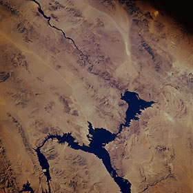
Titre : Lake Mead, Arizona, U.S.A. November 1985
Description : (La description de cette image n'existe qu'en anglais)
This low-oblique, southwest-looking photograph of northwest Arizona and southeast Nevada shows a desert landscape dominated by spectacular features. Lake Mead, formed by Hoover Dam (formerly Boulder Dam), and the Colorado River constitute part of the boundary between the two states. Although Hoover Dam, which was completed in 1936, was originally constructed to provide flood control, irrigation, power, and river regulation, adjacent Lake Mead has become a major recreational site. Increasing tourism and the growing population of Las Vegas, Nevada, (part of which is visible along the right edge of the photograph) have placed heavier demands on Lake Mead. Part of a drainage system—light, linear Detrital Wash—extends southward from the middle of Lake Mead. Using Las Vegas as a starting point, several mountains are visible—to the northeast, the Virgin Mountains on a large peninsula that extends southward; to the east, the Muddy Mountains; to the southeast, the Black Mountains (in Arizona) and Eldorado Mountains (in Nevada), which are located on either side of the Colorado River south of Hoover Dam; and to the south, the McCullough Mountains. The lighter, elongated area southeast of the McCullough Mountains is a dry lakebed (playa).
|
|

